I held in the back of my
mind the realization that the trail gate we found open last time could be closed.
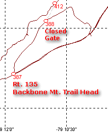
And so it was to be that when we arrived, we found it so. I was very disappointed
since this trail is quite fun. We continued on the gray stone road that eventually
lead us back to the pavement. It crossed to the other side of the road but lead to
closed gates almost immediately so we abandoned hope of gaining access from this end.

Instead, we drove around on
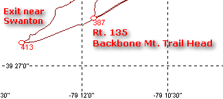
Savage River Rd. to the exit end of the trail. Just as we reached the turn-off to
the trail entrance, we passed the reservoir and dam. A brand-new chain-link fence
surrounds the dam and water, and the area is posted. This, in the wake of events of
September 11th. How very sad that this view is marred by a fence to prevent
terrorism...
Truth be told, this trail is
probably more interesting run in this direction anyway, so I didn't feel bad when we found
this end of the trail open. Up we went onto the side of the mountain, climbing
through switchbacks with sheer drops off to one side.

© 2001 Kelsey Smith Photo

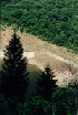
This is a steep
mountainside. Looking almost straight down, one can see the railroad bed and a road
below, small strands marked here and there with dots that are really small houses.
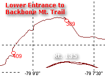
The railroad
has an interesting story all its own:
Updated info 6/29/04:
Near the spot where we went down to the railroad grade is Hitchcock Tunnel
and near that, Strecker, a switch location. I found this article
on
the web and archived it against loss:
Mountain Subdivision - 17 Mile
Grade
With the leaves nearly gone, the view is breath-taking, and the severity of any mistake
that takes you off the trail, painfully obvious.

© 2001 Kelsey Smith Photo
I am starting to realize
that I may have a fear of heights because these places, while very rewarding to visit,
seem to place great fear in me. It is not so bad that I cannot function, but it
makes me acutely aware of what I am doing, and the consequences of a mistake.


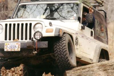
I have no doubt that if one
wheel got off the side of these kind of trails, that the Jeep (and contents) would be a
pile of wreckage at the bottom in short order.


© 2001 Kelsey Smith Photos

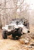


Fortunately, the trail is
wide enough for the width of almost two Jeeps so that making a mistake would be pretty
stupid. As we travel at speeds under a couple miles per hour, it would take several
seconds to get close enough to the edge to be at risk.


So don't go fishing for that
magnetic CB antenna mount that flopped over, or that cassette tape case that you want to
poke around in, or it could be BUH-BYYYYYYYYEEEEEE---

© 2001 Kelsey Smith Photo
Still, in some spots, there
is one surface condition or another that requires moving away from the side of the
mountain, and care and alertness are the order of the day.


© 2001 Kelsey Smith Photos
So with this kind of
attention demanded, we tip-toed our way along the trail, dealing with muddy spots, fallen
branches, protruding rocks, and a great abundance of fallen leaves.


© 2001 Carl & Kelsey Smith Photos


About noontime, we stopped
at a nice spot for a lunch break. I broke out my camera and everyone had something
to eat.
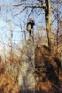
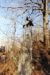
Then, one by one, starting
with Hugh, the travelers climbed the side of the mountain to the top of a large rock/cliff
that jutted out above us. It was nearly straight up, with not much but small trees
to provide handhold. The ground is really soft and provides no traction.


© 2001 Carl Smith Photos


I struggled up a few feet to
make a couple pictures and then came right back down. With my camera to hand I did
not have the flexibility needed to climb around. Fortunately there were no mishaps
and everyone got back down to the Jeeps without event. We continued along to where
the trail descends to the railroad bed. Everyone decided to bypass it except me, so
I ended up riding tail gunner for a while.
After some time of driving
the trail it became apparent that returning this way was not going to be desirable.
We didn't really have any troubles ascending the trail but with all the loose leaves,
coming back this way would be very tricky. No one wanted to come down these hills
with the risk of slipping on the leaves.

We came to one of two
turnouts that provide a nice camping area and lookout.


© 2001 Kelsey Smith Photos


We stopped at the first one,
looked around, made some photos, then continued along to the second of these spots.
Here we found the trail that led out to the gate we found closed earlier - no need to take
that branch... To the right of this was another trail that led west for a couple
miles. The map showed it coming out near Swanton so we chose to try this way to get
out.
At this time, Hugh thought
he had lost something so he and Jim went back to see if they could locate it at the last
stop. I took this opportunity to stretch my legs and look around. It is a
beautiful spot, the kind of place that is great for contemplative times, and very welcome
to me on this day. Shortly, Jim and Hugh returned with all possessions accounted
for, and we continued along for a ways.
Soon we came to a spot where
a decent-sized tree had fallen across the trail. It looked like many trail users had
been able to continue under it, but both Jim and I, with our overhead racks, would have no
chance of making it underneath, indeed, I doubt that Carl and Hugh would either.
I should mention that Carl
had asked me, before we left, if there was anything I would like him to bring along.
I have often considered bringing my chainsaw but it's messy and heavy and I usually
don't bring it. I have been eyeing the camp "buck" saws that I see at
Wal*Mart and have put off buying one (for who knows what reason). Anyway, I
suggested that if he had one, to bring along a saw. Long story short, Carl brought
the saw and probably saved us a lot of time and hard work. Even before we came to
this trail-blocker, we had pressed the saw into use, to ease us by a couple spots where
fallen branches blocked the way.


© 2001 Kelsey Smith Photos
Here, we discussed our
options and agreed to clear just enough of the large tree to make a passage over a very
rough eroded section of the trail. It was to be our "obstacle" for the
day. After we cleared away the portions of tree that we cut, we put some stones in
the low holes, cleared some dry grass to make it easier to see the ground and prevent
fire, and discussed lines.

© 2001 Kelsey Smith Photos
As I was trail leader at
that point, I got to make the first try. About half-way through, I got up against a
rotten log that prevented me from continuing. So I got out and moved it out of the
way, and was then able to "bump" my way up the stepped rubble, and get my
passenger side front wheel back up on the flat portion of the trail. I had just
enough momentum that I climbed out of the erosion back to solid ground. Fun.
Easier than it looked, but the hardest section of trail today.


Next came Carl. He got
hung up briefly at the same spot that I did, but was able to back off and get a little bit
further. I am not sure how his approach differed from mine, but I think he may have
stayed in the mess a little bit longer than me.

© 2001 Kelsey Smith Photo
He ended up getting hung up
with his power wheels lacking bite. When it got to the point that he could not move
forward or backward, and attempts to get something under the wheels failed, I gave him the
strap and tugged him out. No great drama. Just one example of how it pays to
have people along. Carl with his saw, and me with my strap.

© 2001 Kelsey Smith Photo
Hugh observed and took
advantage of our respective attempts and made a cake walk out of it, climbing right
through it, without a hitch. Hugh attributed his great success to his
newly-installed disconnects!

© 2001 Kelsey Smith Photo

Next came Jim, who met the
same snag as Carl and me, but with just a quick backing off, was able to blip past and
climb out nicely. This was our big challenge for the day and it came out well for
all of us. After we stowed all our gear, we moved on.


© 2001 Kelsey Smith Photos


We came upon a fork that
lead in two directions. After a brief exploration, we chose the right fork and soon
came to a large dump area, looking to have been in use for many years before the park
managers closed access to it and placed a very blunt sign at the site.
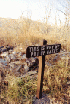
The sign actually
said something like "This is why we put up gates".
Ouch. It was, to be fair, a huge mess. I commented that we ought to
volunteer to clean it up, and then Carl called our collective attention to the true scope
of the problem. The pile extended several hundred feet down the side of the
mountain, and was several dozens of feet wide. This would require a mammoth effort,
beyond our abilities and resources. Very depressing.

Directly behind this site
stood a very well constructed stone wall and four very tall posts that appear to have
supported some sort of platform. One of the posts had fallen down, but three remain
erect. This is probably some sort of historic location, possibly left over from
logging or mining operations. Such a shame to have a spot like this marred by
careless dumping.
The trail was pretty easy
from here on out, a sign that we must be reaching pavement. And sure enough, we came
upon the road in short order. After a quick discussion of what to do next, we headed
for Allegheny. Just up the road, I shimmied my steering to shake any loose dirt off,
and my cooler made a dramatic dive for the pavement. I retrieved it and we drove on
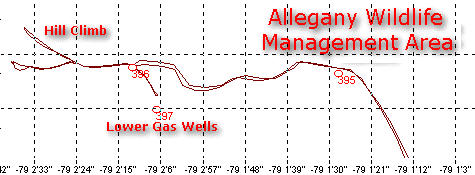
through Westernport and Keyser, to Allegheny Wildlife Management Area.