|
July 2, 2007 |
July 3,
2007 |
July 4,
2007 |
July 5,
2007 |
|
Road
Trip, Charleston WV |
Geocaching,
Off-road to Thurmond, More Geocaching |
New
River Gorge, Long Point Trail, Fayetteville Fourth of July
Fireworks |
Babcock,
Offroad, Beckley, Trip Home) |
Tuesday
July 3, 2007
We got
a lazy start. I lit another fire to warm up and dry out the
cabin. Maria made a nice breakfast with the supplies we
brought. The kids rode their bikes a little bit, and joined us
for bacon and eggs, with coffee and juice. We took our time
organizing our stuff and packing for the day. We decided to go
explore the park and fit in a couple Geocaches.
I wanted to go
visit the site of the old town of Sewell, located on the western
boundary of the park. The map shows a road leading all the way
there so I was hoping to drive there. A write-up I found about
it indicated it was passable with a car so I was not concerned about
the capability of the Commander to deliver us safe and sound.
We stopped first
at the park headquarters. While there I made a couple images
of the Glade Creek Grist Mill from a couple different angles.


Then we drove down the road indicated that would
lead us to Sewell. Along the way we saw several more cabins
set into the hillside between the road and Glade Creek. There
were people out walking, enjoying the weather. Pretty soon we
came to a gate that closed off the rest of the road to Sewell.
I had already checked the terrain on the map and knew that it was a
10.6 mile round trip with the trip in downhill and the trip out
uphill.

This pretty much meant we would spend all day
walking and even on bikes, it would have been a little more than we
wanted to get involved with. So we turned the Commander around
and headed up the hill to see the picnic area, lake, pool and
pavilions up on the hill.
On the way back we stopped at a parking area for the
upper segment of the Island in the Sky trail and took a walk in
search of
the geocache there. The trail was nice and easy from where
we started and pretty soon we reached the cache location.


We checked out the contents, took some stuff and
left some stuff, including a personal Jeep travel bug. The we
continued on the trail to the pavilion that sits on the point at the
end of the ridgeline. It truly is an Island in the Sky - well
worth the hike! We took in the view, and a break with snacks.


At 12:10 we walked back to the Jeep. We left
the park and at 12:37 reached Berry Mountain Road near Layland
Heights. I had identified this as an interesting alternate
route to Thurmond. It's too bad I didn't notice the geocache
along the way - I could have snagged another! The road was
mostly passable with any vehicle though a few rough spots make us
thankful for the Jeep. After a while we got to the little
community of homes on the hill above Thurmond.
I stopped and parked near the Thurmond Union Church
and we began our exploration of the deserted town of Thurmond.


We learned that the church is privately owned and
the home behind it was sold to the Park Service. We got back
in the Jeep and threaded our way down to Thurmond.


As can be seen from the images, the Park Service has
preserved the Depot and is in progress of restoring some of the
other buildings. During our visit, three trains came through,
bearing evidence that this location still has some relevance even
though the steam engines and mineral operations that established
this town no longer provide a viable source of income for anyone who
might want to live here.
We visited the Depot which now serves as the Park
Service Visitor Center, complete with a few exhibits to show how the
Depot once served the community.


Outside we took some time to watch the railroad
operations and check out the bridge.


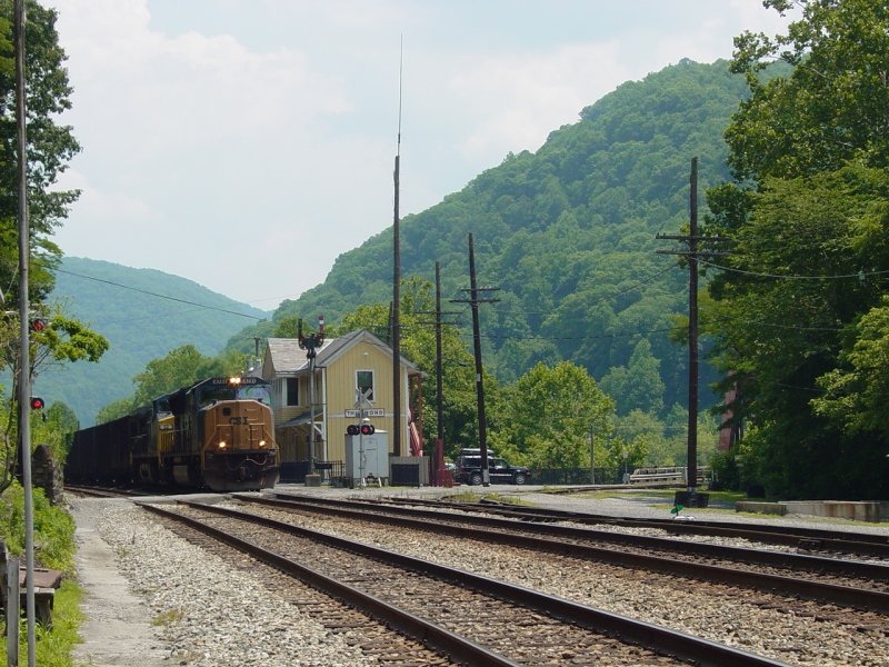


We took a walk along the side of the tracks to the
center of town, such as it is. A row of well-preserved,
turn-of-the-century buildings remain from what was once Thurmond.
There appear to be efforts to preserve and even restore some of the
buildings.


There are some storefronts and a couple banks.


We could not agree on what this structure is...
  

Here are a couple municipal buildings.
 
I made a few images of Tom standing in front of the
mystery structure.


Further down the tracks, more buildings...


And another train coming through. It
definitely is not a good idea to turn your back on these tracks as
they are very active!


Some more images showing the details of the
buildings...


As we returned to the Depot, another train came in.
This one was leaving a car with logs on the side line. This
involved going past the switch, removing the "derail" (used to
protect the main line) and back the car to be left, onto the side
line back on the other side of the bridge.


As the log car passed by my location, it snagged one
of the telephone lines and tore it down. I didn't notice it
but Maria pointed it out so I could avoid being hit by it. We
reported it to the Park Service who passed it on to the train, and
not long after, a CSX crew driving a truck equipped to drive on the
rails showed up.
We loaded into the Jeep and headed down the road
across the bridge. I set a course for Concho Overlook, the
location of the next Geocache I was seeking, and also the location
of a splendid view of Thurmond. As we neared the overlook we
encountered a nasty mud puddle. I checked it with a stick on
the advice of my kids and determined that we could safely drive
through it. The road beyond led up a hill, through a little
mud, and to a clearing with a tent. We parked and walked down
to the overlook.

 
While Maria watched the kids I located
the geocache. Since I was not sure precisely where it was,
and the footing was a little dicey in places, I didn't want them
following me around and falling off the bluff... I found the
cache and called them down to see what it was all about.


I took a picture of some geo-swag and the Commander
and we were on our way.
  

On the way out we swung into the
Ace
Adventure Center. Wow! There we hundreds of people
there. It looked like there were training sessions for
white-water rafter trips, teams getting ready to go rafting, canoes,
camp sites, a huge water park with slides and other things. We
checked the rates for swimming and decided it would be cheaper to
stay here some time and get it that way.


We visited the store and found good deals on some
walking shoes for Maria, stickers and a hat for me, and for Ted,
some clothes for his Care Bear. We resisted the good scents
coming from the dining hall and got back on the road. Our
route back to Babcock took us over the New River Gorge Bridge, so we
stopped at the Visitor Center and took in the more difficult (though
not as hard as the warnings at the top made it sound) Overlook.
There were several steps to get down to the deck but it was easier
than the steps going down the bluff to the lake at our house, so we
all made it without much trouble. The view was worth the walk!


At the base of the canyon can be seen the Tunney-Hunsaker
bridge that was restored to connect the two parts of Fayetteville.
I decided to check the map later and get us down there for an even
better view of the bridge!


A teenage stranger sharing the observation deck with us
decided the deck was not good enough, and climbed over the railing and
down to the rock precipice that the deck was built on. The drop
from there to the canyon road below was considerable, and his father so
apprised the boy of that fact. I kept my mouth shut but this is
the kind of irresponsible behavior that leads to tragedies and
subsequent "dumbing down" of attractions like this to prevent further
"Darwin Awards". This is why we have chicken wire on top of the
Empire State Building and CN Tower. Because people seem to have
trouble observing reasonable boundaries... The teenager was about
to repeat his performance when his mother reached the deck. Better
judgment arrive with her and the behavior was quelled...
With that we took our two observant and curious boys
back to the top of the observation area and set a course for the cabin.
It had been a very full day. When we got to camp, we had a bar-b-que'd
dinner and called it a night. We decided that on
Wednesday, we would
go see some more of the bridge from the bottom of the canyon, and hike
the trail to Long Point for yet another view of the area. We had
not yet decided how to celebrate the Fourth of July, but that took care
of itself...
Activities
|
July 2, 2007 |
July 3,
2007 (top of this page) |
July 4,
2007 |
July 5,
2007 |
|
Road
Trip, Charleston WV |
Geocaching,
Off-road to Thurmond, More Geocaching |
New
River Gorge, Long Point Trail, Fayetteville Fourth of July
Fireworks |
Babcock,
Offroad, Beckley, Trip Home) |
Babcock State
Park
GPS Data
Update 1/5/2008:
GPS Data now provided in GPX format for easy transfer to your GPS!
Purchase
GPS Waypoint data and access to topographic maps of this trail using Pay
Pal!

GPS Waypoint data is now available for a moderate fee ($10.00 U.S.).
This contribution allows us to maintain this web site, collect and
maintain GPS waypoint data, and periodically verify its accuracy.
All GPS Waypoints have been verified in the field.
If
you would like to purchase the coordinates for this trail, simply
complete the two questions below and click "Buy Now" to pay for your
purchase using Pay Pal.
For a free sample of how our GPS data is presented to our customers, click here.
IMPORTANT -
After you pay with PayPal be sure to click the orange button
shown circled below from the PayPal Payment confirmation Screen
to go to the GPS Data you purchased!

|
